Batam looks compact when it is squeezed onto a phone screen. That impression causes a fair number of poor hotel choices, rushed ferry transfers and day plans that involve more time in a car than expected.
Nagoya and Batam Centre are separate parts of the city. Harbour Bay and Batam Centre are different ferry terminals. Nongsa is a large northeastern district, not a single resort compound. Barelang begins south of the main urban area and continues through several islands.
Use the map to settle three things before booking: your arrival terminal, your hotel district and the direction of any longer day trip.
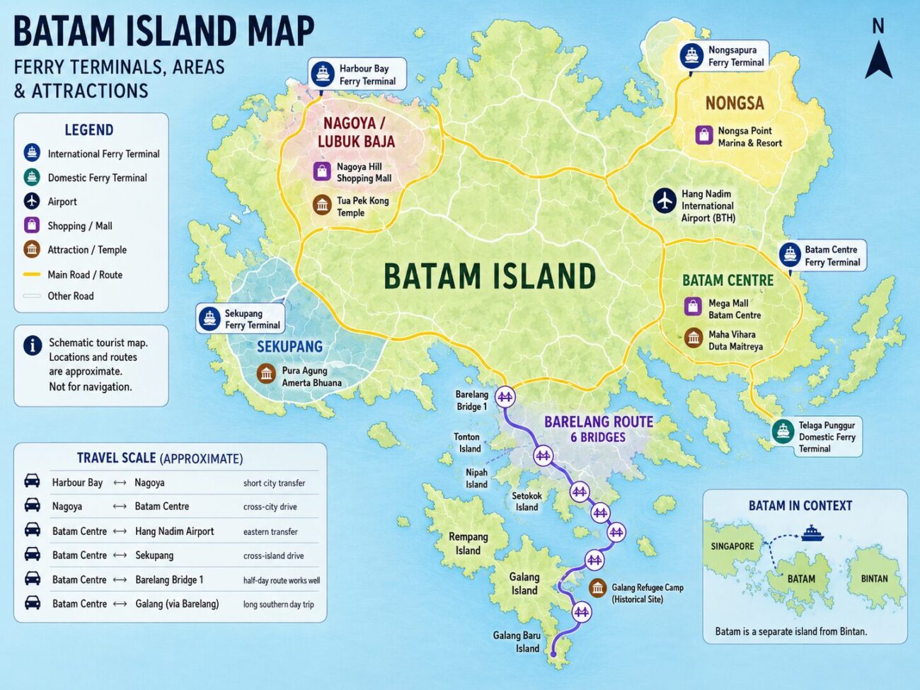
This should be treated as a planning map rather than a promise of exact driving times. Traffic, rain, roadworks and the position of the actual hotel entrance can all change the journey.
Batam Map in Thirty Seconds
Nagoya: the main city area for hotels, shopping and restaurants.
Harbour Bay: a ferry and waterfront district close to the Nagoya side of the city.
Batam Centre: a separate ferry, business and government district farther east.
Nongsa: the northeastern resort area, with Nongsapura Ferry Terminal nearby.
Sekupang: western Batam, with its own ferry connections.
Barelang: the southern road through bridges, Rempang and Galang.
Batam Island Areas at a Glance
Batam City is larger than the main island shown on many tourist maps. Its administrative area also covers Rempang, Galang and smaller surrounding islands. Most short visits, though, revolve around a handful of practical zones.
Main Areas on the Tourist Map
These are planning zones rather than a complete list of Batam’s administrative districts.
| Area | What it is | Best for | Common mistake |
|---|---|---|---|
| Nagoya / Lubuk Baja | Main commercial and hotel district | Shopping, restaurants and first visits | Treating Nagoya as a separate city |
| Harbour Bay | International ferry and waterfront complex | Short stays near Nagoya | Confusing it with Batam Centre |
| Batam Centre | Administrative and commercial district | Ferry access, Mega Mall and business | Assuming it is central to every attraction |
| Nongsa | Large northeastern district | Resorts, golf and Nongsapura arrivals | Assuming every resort is beside the terminal |
| Sekupang | Western Batam district and port area | Western routes and quieter stays | Using it as a base for daily trips east |
| Barelang | Southern bridge and island route | Rempang, Galang and scenic drives | Treating Bridge 1 as the whole route |
The Main Tourist Areas on the Map
Nagoya, Lubuk Baja and Harbour Bay
Nagoya is the name travellers usually use for the commercial district around Lubuk Baja. This is where you find Nagoya Hill, a large share of Batam’s city hotels, restaurants, spas and late-night businesses.
Lubuk Baja may appear in the formal address even when a hotel describes itself as being in Nagoya. The two names are not competing destinations. Nagoya is the better-known tourism and commercial label within the wider district.
Harbour Bay sits to the northwestern side of this city cluster. Its ferry terminal, hotels and waterfront restaurants form a separate complex, but Nagoya is usually a relatively short drive away in ordinary traffic.
This is the most convenient part of Batam for a short city break. A traveller can arrive through Harbour Bay, stay near Nagoya and combine shopping with dinner without crossing the entire island. The guides to Batam hotel areas, shopping in Batam and where to eat explain the choices within this cluster.
Batam Centre and Batam Kota
Batam Centre is not another name for Nagoya. It is a separate eastern district built around the international ferry terminal, government offices, Dataran Engku Putri, Masjid Raya Batam and Mega Mall.
Maps and addresses may also use Batam Kota or Teluk Tering. Teluk Tering is the area containing the ferry terminal, while Batam Kota refers to the broader administrative district.
Batam Centre is practical for passengers using its terminal and for business appointments in the eastern and central parts of the city. It is less useful for someone who expects to walk to Nagoya restaurants each evening. That requires a car.
The area is also well placed for Maha Vihara Duta Maitreya. Other religious sites sit closer to Nagoya or Sekupang, as shown in the guide to Batam’s main temples.
Nongsa, Nongsapura and Hang Nadim Airport
Nongsa covers a large section of northeastern Batam. It includes resort coast, golf courses, villages and the wider airport side of the island.
Nongsapura is the name of a specific international ferry terminal serving the resort zone. It should not be used as a general substitute for Nongsa. A resort may offer a short transfer from Nongsapura, but that does not mean every property is within walking distance.
Hang Nadim International Airport, code BTH, is located in Batu Besar on the eastern side of the Nongsa district. It has a fairly direct connection toward Batam Centre. Trips to Nagoya, Harbour Bay, Sekupang or Waterfront City cross more of the urban area.
Nongsa makes sense for a resort weekend, especially when arriving from Singapore through Tanah Merah and Nongsapura. The Tanah Merah Ferry Terminal guide covers that departure route, while the hotel guide compares Nongsa resorts with city accommodation.
Sekupang and Waterfront City
Sekupang occupies the western side of the main island. It has passenger ferry facilities, residential areas and access toward several western Batam destinations.
Pura Agung Amerta Bhuana is also on this side of the island, making Sekupang more practical for that temple than Nongsa or Batam Centre.
Waterfront City lies farther south. Despite the name, it is not Batam’s central waterfront district. It is a resort and residential zone associated with Teluk Senimba, large hotel compounds and western road connections.
These areas work when the ferry, resort or event already points west. They are poor choices for a traveller planning repeated trips to Nongsa or Batam Centre.
Ferry Terminals and Airport on the Batam Map
The Terminal Name Controls the Transfer
A ticket showing only “Batam” does not provide enough information. Harbour Bay, Batam Centre, Nongsapura and Sekupang are separate arrival points.
Choose the ferry after checking the hotel area. Saving a little money on the ticket is rarely worthwhile when it creates a long transfer with luggage.
Harbour Bay Ferry Terminal
Best placed for Harbour Bay hotels, Jodoh, Batu Ampar and the Nagoya side of the city. It is a strong choice for a short urban visit.
Batam Centre Ferry Terminal
Best placed for Batam Centre, Mega Mall, government offices and onward travel through central-eastern Batam. It is not beside Nagoya.
Nongsapura Ferry Terminal
Primarily used for Nongsa resorts and services connected with Singapore’s Tanah Merah terminal. Confirm whether the resort transfer is included and whether advance booking is required.
Sekupang Ferry Terminal
Useful for western Batam and selected domestic or international routes. It should be chosen deliberately rather than because its departure time happens to look convenient.
Telaga Punggur
Telaga Punggur is an important domestic ferry hub on the southeastern side of Batam. It is used for connections toward Bintan and other islands. It is not the normal international arrival point for a first-time Singapore city break.
Hang Nadim International Airport
The airport is in eastern Batam. Save the hotel’s map pin and district name before arrival. Drivers may recognise a major property immediately, but small hotels with similar English names can cause confusion.
Barelang, Rempang and Galang
Barelang is short for Batam, Rempang and Galang. It refers to the southern island chain connected by six bridges, not only to the large bridge that appears in most tourist photographs.
The first crossing, Tengku Fisabilillah Bridge, is commonly called Barelang Bridge 1. It is a realistic stop on a shorter outing from the city. The road continues through Tonton, Nipah, Setotok and Rempang before reaching Galang and Galang Baru.
The former Vietnamese refugee camp is on Galang, much farther south than Bridge 1. A map that compresses the whole chain into a small tail makes the trip look deceptively easy.
Bridge 1 Is the Start, Not the Whole Barelang Trip
A quick photograph at the first bridge and a drive through the full island chain are different plans. Reaching Galang involves many more kilometres of road.
Do not combine a full Barelang day with a rushed list of Nagoya shopping, Nongsa resorts and an evening ferry. Choose one direction and give it enough time.
The separate guide to the Barelang Islands covers the bridges, southern stops and the decision between a short bridge visit and a longer drive to Galang.
What Looks Close on the Map but Is Not
- Nagoya and Batam Centre. They are separate urban districts, not one walkable centre.
- Batam Centre and Nongsa resorts. They share the eastern side of the map, but resorts can still require a substantial road transfer.
- Sekupang and Waterfront City. Both are in western Batam, but they are not the same terminal or resort complex.
- Barelang Bridge 1 and Galang. The first bridge marks the beginning of a much longer southern route.
- Hang Nadim Airport and Harbour Bay. They sit on different sides of the main urban area.
- Batam and Tanjung Pinang. Tanjung Pinang is on Bintan Island. A ferry ticket there does not take you to a Batam hotel.
- A map pin and a walkable entrance. Wide roads, missing pavements, heat and luggage can make a short-looking route unsuitable on foot.
How to Use the Map to Plan Your Stay
One-Night City Visit
Match the ferry terminal to the hotel. Harbour Bay and Nagoya make a simple combination. Batam Centre also works when the ferry arrives there and Mega Mall is enough for the shopping part of the trip.
Skip Barelang. A one-night visit does not need a southern road expedition unless that is the entire reason for coming.
Nongsa Resort Weekend
Use a Tanah Merah to Nongsapura route when it suits the resort. Confirm the transfer, then plan most of the stay around the property and northeastern Batam.
Repeated trips into Nagoya are possible, but they weaken the logic of paying for an outlying resort.
Two or Three Days in Batam
Use one day for the city: Nagoya, Harbour Bay or Batam Centre. Put Barelang on a separate day. Add Nongsa only when a beach resort, golf course or specific northeastern attraction genuinely interests you.
The map is most helpful when it removes things from the itinerary. Not every district needs to be visited.
Common Batam Map Mistakes
- Booking a Harbour Bay hotel with a Batam Centre ferry without checking the transfer.
- Assuming Batam Centre is the middle of every tourist area.
- Reading Nagoya and Lubuk Baja as two unrelated places.
- Confusing Nongsa district with Nongsapura Ferry Terminal.
- Buying a Tanjung Pinang ticket for a Batam stay.
- Labelling the first Barelang bridge as the entire island route.
- Using an old map that still shows renamed hotels or inactive routes.
- Planning a journey from straight-line distance rather than the road network.
- Relying on walking directions between large districts.
Frequently Asked Questions
Where is Nagoya on Batam Island?
Nagoya is in the northwestern urban part of Batam, within the wider Lubuk Baja area. It is comparatively close to Harbour Bay and is the main district for city hotels, shopping and restaurants.
Is Batam Centre the centre of the whole island?
No. Batam Centre is a named administrative and commercial district with its own international ferry terminal. Nagoya, Nongsa, Sekupang and Barelang are separate areas.
Which ferry terminal is closest to Nongsa?
Nongsapura Ferry Terminal is the main international gateway for the Nongsa resort area. Individual hotels still require a road transfer.
Is Hang Nadim Airport near Nagoya?
No. Hang Nadim Airport is in eastern Batam, in the wider Nongsa district. Nagoya and Harbour Bay lie farther west.
Is Barelang Bridge just one bridge?
The name is often used casually for Bridge 1, but the Barelang system contains six bridges connecting Batam with islands to the south.
Can you walk between Batam’s main districts?
Not realistically. Walking may work inside a mall area, resort or waterfront complex, but travel between Nagoya, Batam Centre, Nongsa and Sekupang normally requires a car.
Use the Map Before You Book
Find the terminal first. Place the hotel beside it on the map, then look at the activities you actually intend to do.
Nagoya, Batam Centre and Nongsa can all be good bases. They simply support different trips. Barelang belongs to another direction altogether.